
June 19th 2022
Ganmukhuri – Kartvani, Georgia
Miles: 90 (150km)
Miles total: 10’320 (16’620km)

Our morning walk consists of just a few hundred meters along the beach until we arrive at the fence with the sign "Entry denied". The border with Abkhazia.
Abkhazia:
The regions of Abkhazia and South Ossetia (20% of Georgia) have been under Russian control since the 2008 5-day war. Abkhazia (250,000 inhabitants) is a region in the south of the Caucasus (on the Black Sea) that considers itself an independent state and is effectively governed autonomously. Under international law, however, Abkhazia is considered part of Georgia. However, residents of Abkhazia do not want to belong to Georgia and want to be autonomous. Autonomy is recognized almost exclusively by Russia. However, Abkhazia is dependent on Russia, both economically and militarily. You can find more about this interesting topic and the wars in 1992/93 and 2008 on the Internet.


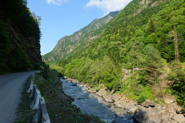
Continue driving. The road towards Svaneti, towards the Greater Caucasus, begins to climb and soon we make a small stop.
Enguri Dam:
One of the ten highest dams in the world. 889 feet (271m) high! The Enguri Dam was completed in 1988 after 20 years of construction! The hydroelectric power station provides 40% of all electricity for Georgia.


Another part of the electricity comes from other smaller hydroelectric power plants and the rest is imported from Russia. Now to the speciality of this power plant. The lake and the dam are in Georgia. The water now goes through a 9-mile-long (15km) long tunnel and the turbines are in Russian-occupied Abkhazia! Since both sides are dependent on each other, Georgia continues to get electricity and Abkhazia gets electricity for free.
We get all this information during a guided tour (three of us) from the young Georgian Mary!
It continues along the roaring, dark gray Enguri River deeper and deeper into the beautiful, green Enguri Valley. We do not reach our today's destination Mestia.
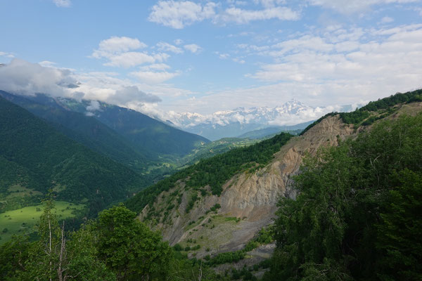
One of the reasons is a construction site where rubble and stones are being removed, and we lose almost an hour waiting and chatting with other tourists. In addition, around 8:00 p.m. we see a flat place along the road with a wonderful all-round view of several mountains. Since there is hardly any traffic, we spend the night here.
June 20th 2022
Kartvani – Mestia, Georgia
Miles: 20 (30km)
Miles total: 10’340 (16’650km)

Wonderful view of the mountains during breakfast. This is how a good day begins :-).
Only 19 miles (30km) on a reasonably usable road and we arrive in the extremely touristy mountain village of Mestia. Since we have to do laundry (a load is already in our in-house wide-mouth drum washing machine), we are looking for a campsite.


The first one, although well rated on Park4Night, we didn't like it at all! Tight and squeezed in! But there is also a campsite next door (no ratings), so we ask. Lo and behold, we can spend the night on a beautiful meadow in front of the house with a clear view and lots of space :-). So, we are completely free on an open meadow while the neighbor's four mobile homes are cooped up with no view. To each his own!
Now a happy surprise. The 11-year-old girl from the campsite brings us a welcome gift. A small necklace and a drawing of our camper on their pitch. The drawing is so cute and detailed that even the t-shirts on the laundry-line at the camper have the right colors :-).


Since the weather forecast only says sun today and tomorrow, we decide to take an afternoon trip by gondola to the Hatsvali ski area, where we hike for a few hours along the ridge and have a great view of Mestia and the surrounding area.
June 21st – 23rd 2022
Mestia, Georgia
We start our hike directly from the campsite at 6 a.m. It is still quiet in the village, apart from active people who are already working in their gardens. We will not be forgiven, the hike begins with a steep three-hour climb that has to be mastered over 3300 feet (1000m) in altitude. Luckily, we get a bit distracted by our three "guide dogs", Blue, Sheriff and Nose, who joined us just after the village :-).


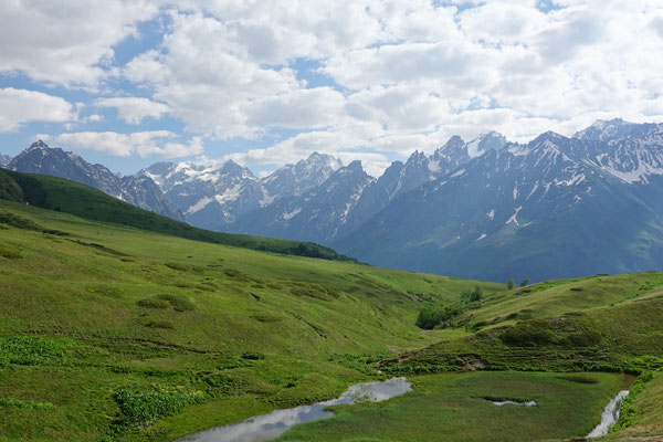
As soon as we have mastered the first stage and we come to the forestless alpine area, a great mountain panorama opens up for us. The scent of the yellow azalea and the many alpine herbs excites us even more. Along meadows full of flowers, the path now leads a bit over a gravel road, which is also used by many tour buses that drive to the Koruldi lakes further up.


We soon leave the road again, hike comfortably along a long, slightly rising flank, pass a wide ditch still filled with snow and finally tackle the last 2000 feet (600m) in altitude to the Guli Pass. Luckily, three Frenchmen meet us during the ascent, so we finally know that the pass is actually accessible... Our loyal animal companions are also happy about the encounter, after more than four hours of ascent and 4600 feet (1400m) of altitude difference, they have slowly enough and now like to tackle the way back with the French. We were a bit worried that we would have to take the dogs back to Mestia by taxi ;-). We continue to fight our way up the steep slope, the path soon disappears under the remains of snow and we look for the best possible way up to the ridge.


From there another short ascent and then: finally done! Welcome to the 9691 feet (2954m) high Guli Pass! The sufferings were worth it, we enjoy a fantastic all-round view over the mountains of Upper Svaneti and the double peaks of Ushbas, unfortunately overcast, one of the most famous mountains in the Greater Caucasus. But of course, our hike does not end here. The descent leads us into the Becho Valley, through a white carpet of blooming Caucasus alpine roses. A dream!


Unfortunately, the weather is slowly changing. Just as we reach some empty shepherd's huts, it starts to rain and we can take shelter there. Soon after, two locals come along who really want to take us down to the valley with their horses. If we then also took their taxi service back to Mestia, the horse ride would even be free :-). We decline with thanks, although the taxi service wouldn't be completely out of the question, since we still have no idea how to get back to Mestia. The rain stops and we tackle the last part of our hike. Together with a huge herd of cows we arrive at the bottom of the valley near the village of Maseri. We sit down on the side of the road and try our luck with hitchhiking. Unfortunately, there isn't much traffic... Maybe we should have accepted the horse driver's taxi service after all ;-). After an unsuccessful half hour, we continue on foot. After about 10 minutes, a nice gentleman takes us 3 miles to the main road. And half an hour later we are sitting in another car that is taking us back to Mestia. Happy but dead tired we arrive in Mestia at around 7.30pm, just in time for a delicious dinner in one of the many restaurants. As forecast, the next two days will be relatively rainy. We recover from the hike and explore the village of Mestia, the "capital" of Upper Svaneti.


The symbol of the region is certainly the Svanetian defense towers, the remains of a unique defensive structure from the early Middle Ages. The 65 – 80 feet (20-25m) high towers were mostly built right next to the houses and were supposed to protect against enemies and natural disasters, at the same time they served as signal towers and sentinels. The tower has loopholes on each side. Protection was sought here not only from external enemies, but also from hostile families. Blood feuds were not uncommon here until 100 years ago. The Svans (local svaneti people) were also known to be good fighters. Because of this, as well as the remoteness of the region, treasures from the lowlands were brought to safety here by invaders. It is also very interesting that the Svans still have their own language, which, however, cannot be understood by the other Georgians. During our village walk we visit the birthplace of the well-known Georgian mountaineer Mikhail Khergiani aka "Rock Tiger", where there is a small museum about his life as an alpinist. The traditional two-storey residential building is also very exciting. Residents and their livestock lived on the ground floor, while the first floor was used to store hay. The highlight of the museum visit, however, was climbing the attached defense tower. The view from the top floor of the defense tower would actually have been enough for us, but the museum guard insists that we climb up to the shingle roof :-). Going to the cinema is also an ideal program for bad weather. Yes, there is actually a cinema in Mestia (and also in the nearby Ushguli, by the way)! However, the selection of films is quite limited: the same film is shown 5 times a day and this has been the case for about 5 years ;-). Of course, it's not a real cinema, just a room with a projector and a few chairs and armchairs. The film "Dede" shown was filmed in Ushguli (nearby village), the home of the author and director, and is about the fate of a young woman who rebels against the tradition of arranged marriage. Old customs such as bride kidnapping and deadly family feuds are also addressed in the film. We found the film very interesting and it is definitely worth going to the cinema.

During our stay at the campsite we are witnessing Georgian hospitality. The very lovely owner brings us something from her kitchen every day: Chachapuri (Georgian cheesy bread), yoghurt or freshly milked milk. By the way, the family owns a cow that roams around freely in the village, comes back on its own in the evening, then stands mooing at the fence and wants to go to its stable! However, what saddens us is the fact that we found the campsite owner drunk twice during the three days of our stay...
June 24th 2022
Mestia – Ushguli, Georgia
Miles: 30 (50km)
Miles total: 10’370 (16’700km)
You could also complete the 30 miles (50km) to Ushguli in a well-known 4-day trek, but since the weather is bad, we prefer to take the road and drive up :-). Through the narrow valley it goes up from 4600 to 6900 feet (1400m to 2100m). A deserted but beautiful mountain region, where only a few houses are now and then.


The road is good at first, but becomes a tedious bumpy-mud-stone route in the last 9 miles (15km). Two miles before Ushguli we stand in front of a junction. Left, the reasonably good road; on the right, a small crappy path that goes to the lowest of the three Ushguli hamlets. Since a newer signpost with "Right Way" points to the right, we, as decent citizens, naturally drive on the right! Bad idea, because shortly afterwards we end up in a narrow alley, squeezed between a fence, a building and a hanging power line. We squeeze our way through with inches precision and are stuck again a few yards later. A truck is in the way. A man comes out of a house, tells us that the driver isn't there and asks if I want to put the truck aside myself. We prefer to let it be and wait :-). We're not stressed. Now the man comes out with a glass of stone-fruit liquor, so then cheers. And soon the second glass and a piece of bread with cheese on it :-). Very nice people, but we still can't continue. Suddenly he asks if we have 4x4, shows us a narrow, steep path up to the other street, and we drive off. 4x4, reduction gear and diff-lock in, and we leisurely scramble back onto the right road.
Ushguli:
A cozy mountain village with 75 families (220 inhabitants) at 6900 feet (2100m). Old defense towers alternate with guest houses. Cows, pigs, horses, chickens are omnipresent and the more than 1000-year-old St. George's Church towers over the village. There's even a school. Despite the severe winters, Ushguli is inhabited all year round and can be reached by road.


We also get to see a movie star in Ushguli. We meet the little boy who played in the film “Dede” in front of one of the restaurants :-).
For the night, we go one mile towards Shkhara Glacier, where we still have the feeling of having a quiet night in nature ahead of us. But more on that in the next report.
June 25th 2022
Ushguli, Georgia
As so often on our sleeping places, a lovely but skinny dog joined us yesterday, which we gave some dog food out of pity. He then kindly slept under the Iveco and as soon as it got dark he started barking at the night for no reason and for hours!!! Yelling at him, chasing him away and throwing stones was without success, he stayed near us and kept us more or less awake the whole night with his barking! At 17’000 feet (5201m), the Shkhara is the highest mountain in Georgia and the third highest mountain in the Greater Caucasus. Actually, we would have a clear view of the majestic summit from our sleeping place, but unfortunately, we are denied the view due to the bad weather. If we don't get to see the mountain, we at least want to see the glacier! Despite the persistent rain, we undertake a hike through the Enguri river valley, which leads to the very back of the valley on a rough gravel road. We are in front of the first stream crossing and nowhere is a bridge to be seen. Two little tour buses are just showing up and because there is no space inside the bus, we are allowed to stand on the rear bumper and get across the stream with dry feet. However, despite the bumper, the water was really close to our shoes... The valley widens and we hike towards the glacier on the flat valley ground. Luckily, we master the other stream crossings without outside help ;-). Even the rain stops for a brief moment and a few rays of sunshine find their way through the clouds.


At the very back of the valley, the short ascent begins, until we are soon standing directly in front of the high ice wall of the glacier, where the Enguri River also has its source. An impressive picture! But the weather doesn't invite you to linger, the rain starts again and we tackle the way back. The last quarter of the way we are allowed to sit down on the soaking wet back of a pickup and are really shaken up in the pouring rain :-). Soaked down to our underpants, we return to the Iveco, immediately turn on the heating and have a cozy evening. Despite the miserable night, we dare again to spend the night in this beautiful place...
June 26th 2022
Ushguli – Zagari Pass, Georgia
Miles: 10 (10km)
Miles total: 10’380 (16’710km)
(A film from the Zagari Pass is available under "Videos")
Another night we slept badly! Another night the dog barked at nothing for hours.

In rainy weather, we devote ourselves to this website, have some lunch in the village and visit the pretty 9th or 10th century St. George's Church built entirely of stone at the top of the village.
Not keen on a third restless, dog-barking night, we head up the Zagari Pass in the late afternoon. The pass is notorious as an off-road route and is said to be hardly feasible without a 4x4.


We choose it anyway because on the one hand it's a shortcut of about 60 miles (100km) (and doesn't go back the same way), but more because the scenery has to be amazing! And after all, we have a vehicle with which you can travel such tracks effortlessly. 5 mile (8km) route, one hour. Our Iveco easily masters the usual obstacles such as puddles, stones, mud and steep passages :-).
We arrive satisfied with a little rain and park our car at the top of the pass right next to the "road".
June 27th 2022
Zagari Pass – Okatse Canyon, Georgia
Miles: 90 (140km)
Miles total: 10’460 (16’850km)
Finally! Best weather in the morning. A mountain panorama at its best and we, completely alone, at the top of the 8595 feet (2620m) high Zagari Pass.


We start a short hike to the nearby small church. A picture that could easily decorate a postcard! Finally, we are 1200 feet (350m) higher, at almost 10’000 feet (3000m) and see Georgia from one of its most beautiful sides.


Snow-covered mountain peaks and in the foreground flower meadows that are just waking up from winter. But now we are excited to see how the journey continues on the other side of the pass. Slowly it goes further down the stony passages.


And there it comes, the expected creek crossing. Maryse gets out to capture the whole thing on video :-). Well, the water isn't high, but it's still not quite easy because we have to circle through the countless stones without damaging the tires. Maryse also climbed over the creek on foot and we continue. The 9 mile (15km) off-road route along lush green areas, beautiful flowers and some waterfalls are done.
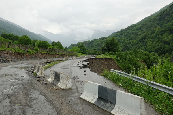


Finally asphalt! However, some dangers remain! There has been a lot of rain in this area in the last few days. This is probably one of the reasons why parts of the road are missing in a number of places. This was partially undermined and a quarter of the width of the street collapsed. We drive past such passages with a queasy feeling. Half-collapsed road on the left, stones on the road to the right from frequent falling rocks. The river is still raging black! In the evening, we arrive at the Okatse Canyon Visitor Center quite exhausted from the drive and park next to our new German neighbors. Unfortunately, another small misfortune happened. Maryse walks to the gate of the restaurant there, 5-year-old Alvin from the German family follows, the restaurant lady opens the gate, her Labrador dog comes out and actually bites the little boy on the leg as he rides away on his bike! But the shock is over quickly, the boy is fine, we eat something small in the restaurant and let the tiring day end happily!
.
June 28th 2022
Okatse Canyon – Kinchkha waterfall, Georgia
Miles: 10 (10km)
Miles total: 10’470 (16’860km)
At 10 a.m. the Okatse Canyon Visitor Center finally opens. Buy a ticket and go. After 2 miles (3km) of walking along the hiking trail through a forest, we arrive at the attraction. The canyon itself, one has to admit, is not the highlight at all. It's beautiful, but for us the special thing is definitely the walkway and the platform, which also gets our adrenaline pumping.


Both the walkway and the platform are suspended high above the ground in the air and you can see the abyss far below your feet. The way back is also on foot along the road, where 4x4 Mitsubishis, filled with tourists, drive the heavy off-road path. The road is also difficult to walk, but it's still worth it.

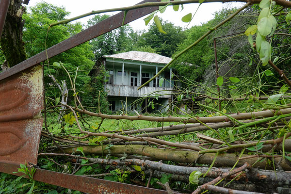

We discover old typical houses that are abandoned and left to nature, we enjoy the generally very natural area and are impressed by the huge linden trees, the wild gardens and natural meadows that we discover here.
Back at the parking lot, we're amazed when it's jam-packed. Apparently, the canyon works quite well together with the platform as a tourist magnet.
Lunch at the local restaurant and 4 miles (7km) further to the next attraction. The Kinchkha Waterfall. This triple waterfall (85ft – 230ft – 65ft / 25m – 70m – 20m) can also be admired from a platform. From the point of view of nature, this fall with its river course and impressive rock walls is more beautiful than the Okatse Canyon!


At the end of the catwalk we discover the local zipline. So let's go, and we'll rush down the 1700 feet (500m) long zipline at 35mph (60kph) :-).
.