
July 26th 2022
Shulaveri, Georgia – Berkaber, Armenia
Miles: 60 (90km)
Miles total: 11’140 (17’930km)
Today we go to Armenia. Crossing the border takes only 1 hour 10 minutes and everything goes smoothly. Leaving Georgia, entry into Armenia, passport control, vehicle registration (25€), vehicle search and car insurance for three months (35€). By the way, there are no Covid rules to be observed! And already we are in a new, unknown country. We decide to take the easternmost road to head south and soon find a fantastic spot above Joghaz Reservoir lake.


A local from the nearby village shows up. We exchange a few words and we already feel welcome in Armenia.
The only thing that gives us a bit of a queasy feeling are the borders with Azerbaijan, which can be seen all around us.
July 27th 2022
Berkaber – Dilijan, Armenia
Miles: 30 (60km)
Miles total: 11’170 (17’990km)
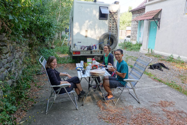
After a short but beautiful drive along the Azerbaijani border, we soon arrive in Dilijan, a cozy mountain tourist resort at 5000 feet (1500m) altitude. Here we will soon meet our good friends Evelyn and Khoa from Switzerland, with whom we can spend a few days in Dilijan. We're really looking forward to seeing them after lunch, but that's not going to happen for the time being! The two are sitting in the bus from Tbilisi and the dear bus driver drives straight on to the capital Yerevan without stopping in Dilijan!!! That's impossible! But the two still make it to Dilijan, just four hours later than planned! We moved into our accommodation in the middle of Dilijan and we fill our hungry bellies with a delicious dinner in a fantastic restaurant.
July 28th – 30th 2022
Dilijan, Armenia
Miles: 40 (60km)
Miles total: 11’210 (18’050km)
Dilijan National Park is one of four national parks in Armenia and is best known for its forests, mild climate, mineral springs, cultural monuments and many hiking opportunities. By the way, the region is also called the "Switzerland of Armenia", which we think is a bit exaggerated ;-). The town of Dilijan and the surrounding villages are nicely situated, surrounded by forest, but are otherwise nothing special. The villages are characterized by agriculture, animal husbandry and possibly fruit growing are predominant.
We spend three wonderful days with Evelyn and Khoa hiking and then feasting in the excellent and surprisingly creative restaurants. The cozy breakfasts in the garden (with ingredients from the Iveco kitchen) also guarantees a good start into the day :-).


On the first day, we take a taxi to the touristy Parz Lake, which is very picturesquely situated in the middle of the forest. Very popular with local tourists in particular, all sorts of things are offered here for their entertainment: boat and pedal boat rentals, restaurants, picnic areas, rope park and zip-line drive away boredom here :-). We soon leave the busy lake and head towards Gosh through the pleasantly cool but mosquito-infested forest. Around noon we reach the highest point: the almost treeless hill with extensive meadow areas offers a beautiful view over the hilly green region.


The hay harvest is in full swing, the small divided areas are in different stages of cultivation and draw a funny pattern in the landscape. The end point of our trek is Goshavank Monastery. Founded in the 12th century, it is considered one of the most important cultural centers in Armenia of its time and has four churches and a library that is said to contain 15,000 books. Here we also meet for the first time the memorial stones typical of the Armenian Church, called "Chachkar". The elaborately carved stone slabs contain a relief cross in the center surrounded by geometric and plant motifs and represent one of the central cultural symbols of the Armenians.


The "khachkar" usually decorate the courtyard of a church or were built directly into the walls of the church. They were erected to commemorate the adoption of Christianity, national holidays or martyrs. One of the finest examples of this art form is at Goshawank Monastery. Unfortunately, we missed this gem because of our eagerness to hike and we only found out about the monastery afterwards...
The next day's hike takes us to the cliffs of the Sartsapat mountain range near the village of Hovk and to the 5400 feet (1650m) high hill of Apakeqar. Today mainly in a forest-free area, we enjoy the wonderful natural meadows with countless flowers and herbs. Always accompanied by the loud chirping of crickets, we admire the vertical cliffs of solid rock, which are rather rare in the region, and enjoy the beautiful views over the villages and the rolling wooded hills.


Unfortunately, the weather isn't quite cooperating: When we arrive high up on the cliffs, large waft of mist appear and settle in the rocks above us. A further ascent does not make much sense and we climb the hill Apakegar further down instead.
The third hike promises to climb three peaks and again goes above the tree line. Well, since we're not in "high alpine" climes, the peaks are more like green hills :-).


Nevertheless, we enjoy the beautiful region with its flower-strewn meadows, hike past rudimentary alpine buildings, where families bring their cattle for the summer and make acquaintance with the young Armenian Sergej, who lives in the region, who likes to explore the landscape on foot and accompanied us for the rest of the hike. On the way back, we also meet the older Dutchman again, whom we met at the beginning of the hike, and who is also joining our growing group of hikers. Back at the Iveco, we all pack our hikers into the car and the six of us drive back to Dilijan :-).
July 31st 2022
Dilijan – Sevan, Armenia
Miles: 50 (80km)
Miles total: 11’260 (18’130km)
We decide to leave Dilijan to spend another day with Evelyn and Khoa at Lake Sevan, the "Armenian Sea". The short drive takes you over a pass road where, funnily enough, there is a stall selling boiled corn on the cob every 300 feet (100m). It must be a lucrative business and apparently there are a lot of corn fields in this area (although we didn't see any...). We drive straight to the well-known monastery on the Sevanavank Peninsula and are overwhelmed by the huge crowd pushing up the stairs to the monastery. No wonder, because the Sevan region is one of the most visited tourist places in Armenia. Many people from Yerevan flee the summer heat and spend their summer holidays or weekends at Lake Sevan in pleasant temperatures. There are countless hotels, resorts and beaches and there are a number of jet skis whizzing around on the water. Lake Sevan is twice the size of Lake Constance, is the largest lake in the entire Caucasus and, thanks to its location at 6230 feet (1900m), is one of the largest high mountain lakes in the world.
The monastery still consists of two small churches that were built in the 9th century and stand on a hill. Sunday mass is taking place in one of the churches, there is a great rush, we don't stay inside long and instead enjoy the fantastic view over the striking turquoise-blue lake and the barren, brown, gently rolling hills in the background.


But the idyll is deceptive: in the 1980s, the lake faced an ecological disaster. It was exploited from 1936 for large-scale irrigation programs and for energy production and its level dropped by 72 feet (22m) by 1988! Algae proliferated explosively, fish stocks fell drastically and wetlands dried up. Taking measures was unavoidable: in 1988, after around 20 years of construction, a 30 mile (48km) long tunnel was put into operation, through which water was diverted from the Ketschut reservoir to the south, into Lake Sevan. Finally, in 2004, a second 13 mile (21km) tunnel was completed, which in turn feeds water from Lake Spandaryan further south to the aforementioned Ketschut Reservoir. With these measures, the situation was finally defused somewhat. The level has risen by at least 8 feet (2.4m) today!
After a short rain, it got a bit cooler and we decided to go for another short hike instead of jumping into the cool water. We discover a chairlift on Google Maps and are already looking forward to making the descent with it. Upon arrival, however, we find that it is no longer operational, although it actually looks passable. We learn from an older man that it hasn't operated for five years. Unfortunately, we cannot find out the reason.

The hike then leads us up around 1300 feet (400m) in altitude into a barren and dry but very picturesque hilly landscape with a wonderful view of the lake. Despite initial difficulties in motivating ourselves, the hardships were well worth it :-).
We spend the evening in a simple restaurant by the lake and enjoy the last hours together. Then it's time to say goodbye to our lovely visitors. We spent four great days together and really enjoyed chatting with friends :-). Evelyn and Khoa spend the night in a B&B in the not very attractive town of Sevan and take the bus back to Tbilisi, Georgia the next morning.
August 1st 2022
Sevan – Shorzha, Armenia
Miles: 50 (80km)
Miles total: 11’310 (18’210km)
Now a tiresome topic! waste and recycling. We try to avoid waste everywhere, but we still can't do without it. In Georgia, we looked in vain for recycling stations and our paper, glass and aluminum collection is slowly getting out of hand in the Iveco! Even in Tbilisi we only found two stations, but they are no longer in operation. That's why we took all the recycling waste that has been piling up for X weeks to Armenia to try our luck here. And there they are, in front of a large modern shopping center on the main street: beautiful recycling boxes, aluminium, paper, glass, plastic. However, the joy is short-lived, because at that moment an employee comes with a large garbage bag, everything disappears into the black bag and later ends up in a landfill. We too are slowly but surely giving up hope!
Now it's time to get our website up-to-date. We fill up with water and stock up on groceries. We drive along Lake Sevan. We often see old hotel complexes from Soviet times or other ruins that fell victim to the collapse of the USSR.


After some search we find our spot. Right on the lake surrounded by forest and far away from the road.
August 2nd – 12th 2022
Shorzha, Armenia
Miles: 90 (140km)
Miles total: 11’400 (18’350km)
11 days at Lake Sevan! We are behind schedule with our report writing for the homepage and finally want to work on this! In addition, we finally don't want to research anything for a day or sort photos, but just have time to read, juggle or watch birds :-). Incidentally, the latter is a unique spectacle here at the lake. Thousands of birds draw patterns in the sky in huge flocks! Fantastic!


Every evening we can observe this; until we get neighbors. Three elderly gentlemen from Yerevan are camping next to us. They invite us over for some dinner one afternoon.

And what's on the plate? rice and a bird! The old-established gentlemen bring their guns and occasionally go bird shooting for dinner! Since then, the wonderful swarms have fled! A shame!
Apart from the bird hunters, our place is absolutely great! Occasionally we even go swimming, although the lake is only about 66°F (18°C)warm.


In the 11 days, we go back to Sevan for two days to attend the “Sevan International Music Festival”. It's really good for the soul, some music and dancing. Musically it was average, but it was still fun :-).


Like the festival in Ukraine a year ago, it's free, and we're wondering how it's going to be financed. The festival takes place over two evenings, each at a different location in the city.
After two nights at the festival, we stock up on our food supplies, fill up the water tank and drive 32 miles (50km) back to our spot by the lake.

Our bird hunting colleagues are also there and invite us again, luckily only for some cheese, bread and beer this time. We return the favor with Swiss chocolate, but the gentlemen are a bit skeptical :-). Really nice guys when they're not hunting.
On our last day, we go hiking. Cross-country without hiking trails: the goal is the 1800 feet (550m) higher mountain Artanisch. The small peak is shrouded in fog, but we still have a great view of the entire huge Lake Sevan. And further on to the smaller Shashasar peak next door, before we walk back towards the camper. When we get home, we go straight into the refreshing lake :-).
August 13th 2022
Shorzha – Hayravank, Armenia
Miles: 100 (160km)
Miles total: 11’500 (18’510km)
Now it's definitely time to move on. By the way, we are no longer the only campers here and for our taste it is almost a bit too full ;-). The site is apparently known to many locals as a "wild campground".

We drive along the eastern shore of Lake Sevan, where there is still a lot of natural shore. We make a stop to fill up water at a spring right on the side of the road. A second car stops: two men who also want to fill up their bottles with fresh spring water. One is a priest and gives us a short sermon, which the other man kindly translates into good English ;-).
A historical sight is also still on the program today. We visit the cemetery of Noratus, which houses around 900 Khachkars (here tombstones; cf. also Dilijan report) and since the destruction of the cemetery in Nakhichevan in 1998-2005 is considered the world's largest field of Khachkars. Most of the tombstones date from the 13th to 17th centuries, with some dating back to the 9th century.


We are impressed by the huge collection of intricately carved stone slabs, all of which face west and yet create a chaotic image.

And we get a very special tour, and a mentally handicapped man has joined us, who is happy to show us the special gravestones and draws our attention to details. We then stroll through the new part of the cemetery and are amazed at the large graves, each individually fenced, with a large concrete base on which stands a mighty gravestone.

Since we haven't completely circumnavigated the lake yet, we look for another quiet spot by the lake for the night.
August 14th 2022
Hayravank – Kari See, Armenia
Miles: 90 (140km)
Miles total: 11’590 (18’650)
planning is pending. How far are we going today? Finally, we decide to take a longer route, up to the starting point for an upcoming hike at the highest peak in Armenia. The weather forecast is perfect, so let's go! Short stop in Sevan for eating and shopping, and further, partly on the highway towards Yerevan, partly on side roads. We see one stand after the other on the side of the road, full of bright orange plastic bottles. Of course, we stop and want to know what it is. It's sea buckthorn juice and we'll buy a bottle. By the way, they only have a few bottles of real juice each, all the other orange bottles are just for show!


We are not going to miss a bizarre sight on the way. The 39 letters of the Armenian alphabet in large stone shapes. The "Armenian Alphabet Monument" was erected in 2005 in honor of the inventor and the 1600th anniversary. Well, that’s something different :-).
Now it's slowly but surely going up hill! Fill up with water at a spring along the road and buy honey and hazelnuts at a stand. We encounter huge flocks of sheep with the associated herd guard dogs. We see the very desolate shepherd's huts and stables where whole families live.


Finally, at 8:00 p.m. at our destination, at Lake Kari at 10’500 feet (3200m)! At the nearby weather station, we are invited for coffee by the station boss Vahan and spend the night above the lake close to the weather station.
August 15th – 16th 2022
Lake Kari, Armenia (hiking to the top of the highest mountain in Armenia)
Day 1: Ruins
Before we tackle the 13’420 feet (4090m) high Mount Aragats, we want to spend a day acclimatizing at 10’500 feet (3200m). We just want to circumnavigate the small Kari Lake and are actually three hours away from home. The old ruins, from USSR times, near the lake attract us and we become curious. First stop, an old observatory housed in a magnificent huge building, all decayed and emptied. We continue and we see dozens of small cubes a few yards (meters) from the ground, which have some measuring devices inside. According to Google, there is a facility for measuring cosmic rays here. Oh well.


But what impresses us the most is a kind of above-ground bunker. Massive steel girders and several thick layers of concrete lined up and under the floor an entrance to the interior! It looks like a cold war spy bunker to us! Unfortunately, the gate to the inside is closed :-). Interesting change from the normal sights.
Day 2: Hike
With a little delay, we start at 6:45 a.m. towards the highest mountain in Armenia! 2600 feet (800m) of altitude up to 13’420 feet (4090m), can we do it? We navigate with “Maps.Me” on our mobile phones, because there are hardly any signposts or waymarks. A barren area lies at our feet, we reach the first ridge and see the four peaks (west, north, east, south peak) of the Aragats volcanic plateau. We head for the highest, the north summit, over the first snowfields. The colors of the rocks are magnificent. Now it is in front of us and the climb is steep! And it's not just steep, the entire flank consists of loose scree!


Somehow, we miss the "official" ascent and soon end up in the middle of steep scree. Concentration is clearly required, because a fall could be painful here. Stones are regularly pushed down the slope. We muck our way up the slope for over an hour! And we do it! We are on the highest peak in Armenia. Unfortunately, this is only half the truth, because we are on the so called "false peak". The real summit is only 200 feet (60m) away and about 30 feet (10m) higher, but the climb is dangerous and we are glad to have arrived here safely! So, we let common sense prevail and enjoy our lunch here with a phenomenal view. From here we can also see the highest mountain in Turkey, the famous Ararat (16’854 feet / 5137m, middle photo), which looks majestically above the haze.


Now, around 2:00 p.m., back towards the camper. We don't feel like taking the same route, so we decide to take a different way back. According to "Maps.Me" it's just 5.1 miles (8.2km). But these have it all, as we will see later.
The descent from the summit is much easier for us than expected, because with each step you are automatically another step lower and have carried down a load of gravel and stones. Through a beautiful valley it goes down towards a waterfall. "Maps.Me" sends us up a steep slope above the waterfall directly to a snowfield that will appear vertical at the bottom. Since we are not suicidal, we turn around and lose more than half an hour.


Finally arriving at the bottom of the valley it is shortly before 6 p.m., but we are still a long way from being back at the camper. There are still 1540 feet (470m) in elevation difference ahead of us, the first 650 feet (200m) of which are steep uphill, before we see a long valley in front of us. Yes, it's very nice, but we both really don't feel like it anymore and are already very tired! At 8:00 p.m., after 13 hours on the way, we finally arrive at our vehicle, completely exhausted after a beautiful but very strenuous hike.
August 17th 2022
Lake Kari – Fort Amberd, Armenia
Miles: 10 (20km)
Miles Total: 11’600 (18’670km)
Before we set off, we want to say goodbye to Vahan. When we arrived two days ago, we somehow got the feeling that he was a little offended because we didn't sleep in front of his house on a totally uneven place, but about 300 feet (100m) further away... But his mood is good and so he immediately invites us to a small snack with bread and cheese! Half an hour later we leave Lake Kari and head to deeper regions. On the way, we visit the Amberd Fortress at 7’550 feet (2300m). The castle, built of massive stones high above the Ararat plain, dates back to the 12th century and is very picturesquely situated in the middle of a confluence of two small gorges.


A small chapel stands daringly at the tip of the promontory. Rather than the castle ruins, the beautiful landscape impresses us here. Since we avoid the hot temperatures as much as possible, we postpone the descent by another day and look for a place to stay with a beautiful view of the fortress.
August 18th 2022
Fort Amberd – Gyumri, Armenia
Miles: 110 (180km)
Miles Total: 11’710 (18’850km)
Well, today we feel like we're in a movie! We landed in the middle of the movie Rambo! A military combat helicopter is approaching us, the missiles visibly attached to the side. Well, they probably don't want to blow us up ;-). During our breakfast outside, the combat aircraft circled our heads for an unbelievable 45 minutes! It's flight education time and they are busy landing and taking off!

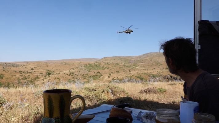
Finally, he flies less than 30 feet (10m) above us and disappears. It's getting too crazy for us too, so we leave and drive near the Turkish border. A region that you will look for in vain in the travel guide.


It is flat, dry, desolate and in the villages at least the huge piles of straw beautify the dilapidated farmhouses. We keep asking ourselves what people live on and how they can survive here.

Hoping to find a place to stay overnight, we make a detour to Harichavank Monastery, which dates back to the 7th century. But there's nothing smart to sleep on far and wide, so we move on to our next destination.
The second largest city in Armenia, Gyumri. We stop in front of the gates of the "black fortress" and before we can switch off the engine, two guys come and invite us for coffee. It's the “black fortress” security. By now, this place is now used as a concert and event hall.

It's already dark and the fortress is closed, but a group of young people who seem to have connections arrive. The security man gets a call from "high above" and so the young team is let in anyway and we can go on the tour right away. At the end, there is a photo session and a guided tour through our camper with the young Armenians :-). Finally, we can have some dinner and go to sleep.
August 19th 2022
Gyumri, Armenia
The city of Gyumri was reduced to rubble in December 1988 due to a severe earthquake. Large parts of the city were destroyed, more than 50,000 people died in the debris and many more lost their homes. The reconstruction of the city took years, and to this day people are said to be living in what are actually temporary living containers. Much of the city's historical splendor was also destroyed by the tragic accident.
During our brief visit to the city, we saw almost nothing of this destruction.


We spend the day in the centre, strolling through the pleasant pedestrian streets with trendy cafes and shops, watching the happenings in the busy Vardanants Square, visiting the historical part of the city where some buildings survived the earthquake and visiting the big market. The black and orange colored Amenaprkich Church on the main square was rebuilt after the earthquake; Finished on the outside, work is still in progress on the inside.


We really liked the city with 120,000 inhabitants, the leisurely pace of the people, not too much traffic chaos and pedestrian zones make the city very pleasant.
August 20th 2022
Gyumri – Stepanawan, Armenia
Miles: 60 (100km)
Miles Total: 11’770 (18’950km)

Before leaving the city, we pay a visit to the "Iron Fountain", a remnant from the Soviet era. The rusty work of art stands abandoned and out of order between factory ruins and residential areas.
We continue towards the Georgian border and spend the night about 12 miles (20km) before the border in the parking lot of the Lori Fortress. Not much is left of the castle; some mighty corner towers and fortress walls testify to the original size. However, the landscape and the location of the castle are also impressive here. Again, this stands on a promontory between the confluence of two gorges.


In what is actually a flat landscape, over the millennia the rivers have dug deep into the earth and formed impressive gorges. Despite the moderate attractiveness of the sight for us, we are surprised how many visitors, mainly locals, come here. While we make ourselves comfortable on the meadow next to the parking lot, the lovely Armenians offered us twice some yummy snacks.
.
August 21st 2022
Stepanawan, Armenia – Tbilisi, Georgia
Miles: 100 (160km)
Miles Total: 11’870 (19’110km)
Breakfast for four. Late last night, Austrians still drove to the site in a normal car and slept next to us. Since there is probably no space for a kitchen in her little Peugeot, we invite them to have breakfast with us right away :-).
And then off to the border. Around noon we arrive at the sparsely frequented border. Leaving Armenia – enter Georgia; an hour and everything worked perfectly. Unfortunately, our old Georgian SIM card no longer works and we end up back in the capital, Tbilisi, since it's Sunday. And since we don't feel like driving at 6PM, we spend the night in the middle of the old town, enjoy a few beers and a pizza in a bar before we get into the way too hot camper.
.